

Traffic Pollution & Carbon EmissionsEMISSION
Traffic pollution is one of the main sources of urban air pollution. Especially for coastal port cities, the frequent entry and exit of a large number of container trucks not only brings huge traffic pressure, but also inevitably generates pollutants such as nitrogen oxides and particulate matter. These traffic pollutants are highly concentrated in port and urban areas, long-termly affecting the respiratory and cardiovascular health of nearby residents, posing serious public health risks. In response to the above traffic pollution issues, the research team has conducted a series of studies in recent years. Main research directions include:

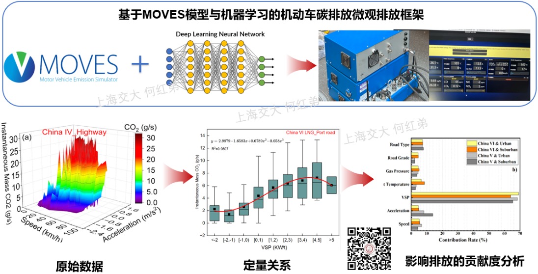


The research group uses Portable Emission Measurement Systems (PEMS) to conduct real-road monitoring of private vehicles (China V, China VI), diesel container trucks (China IV, China V, China VI), and natural gas container trucks (China VI). Based on the MOVES emission model combined with deep learning algorithms, a microscopic vehicle emission model is constructed, and validated using PEMS measured data, ultimately building an AI-powered vehicle emission model. Additionally, a web-based container truck carbon emission calculator has been developed to measure both instantaneous emissions at the micro level and overall emissions at the macro level, achieving refined accounting and dynamic assessment of container truck carbon emissions in Shanghai.
Compared with fixed monitoring, mobile monitoring offers strong flexibility, revealing the risk level of pedestrian exposure to traffic pollution on roads. The research group has invented a smart backpack for portable mobile air pollution monitoring, capable of tracking air pollution concentrations that pedestrians are exposed to in traffic networks. Residents living along streets or pedestrians, due to their proximity to traffic pollution sources, are inevitably exposed to high concentrations of air pollution for long periods, posing significant threats to their physical and mental health. Through mobile traffic pollution monitoring, the research group reveals the spatiotemporal distribution characteristics of urban road air pollutants, assesses the health risks of air pollution exposure for residents and pedestrians, and constructs optimization strategies for traffic and spatial layout of street-side communities. Using PEMS equipment and portable devices, traffic pollution from urban elevated roads, tunnels, toll stations, and other transportation infrastructure is monitored and assessed, providing data support and scientific guidance for the sustainable development of transportation infrastructure.
- He, H.D.*, Lu, D.N., Zhao, H.M., Peng, Z.R. Characterizing CO2 and NOx emissions of vehicles crossing toll stations on highways. Trans. Res. Part D, 2024, 126: 104024.
- Zhao, H.M., He, H.D.*, Lu, D.N., Zhou, D., Lu, C.X., Fang, X.R., Peng, Z.R. Evaluation of CO2 and NOx emissions from container diesel trucks using a portable emissions measurement system. Build. Environ., 2024, 252: 111266.
- Liu, R., He, H.D.*, Zhang, Z., Wu, C.L., Yang, J.M., Zhu, X.H., Peng, Z.R. Integrated MOVES model and machine learning method for prediction of CO2 and NO from light-duty gasoline vehicles. Journal of Cleaner Production, 2023, 422, 138612.
- Wu, C.L., He, H.D.*, Song, R.F., Zhu, X.H., Peng, Z.R., Fu, Q.Y., Pan, J. A hybrid deep learning model for regional O3 and NO2 concentrations prediction based on spatiotemporal dependencies in air quality monitoring network. Environmental Pollution, 2023, 320: 121075.
- Lu, D.N., He, H.D.*, Zhao, H.M., Lu, K.F., Peng, Z.R., Li, J*. Quantification of traffic-related carbon emissions on elevated roads through on-road measurement. Environmental Research, 2023, 116200.
NEV Energy Consumption AnalysisEV ENERGY
In recent years, new energy vehicles have experienced explosive growth, driving the green transformation of transportation while also presenting new challenges. Among these challenges, range anxiety and battery performance degradation have become key factors limiting their further widespread adoption. In response to these issues, the research team has collaborated with the Shanghai New Energy Vehicle Public Data Collection and Monitoring Research Center to conduct systematic research on the energy consumption patterns and battery health status of new energy vehicles, relying on large-scale real-world operational data, providing scientific support for the optimization of new energy vehicle performance and industry development.
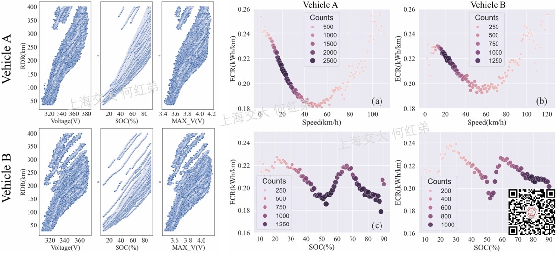
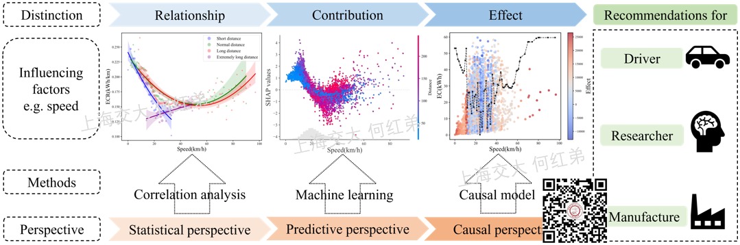
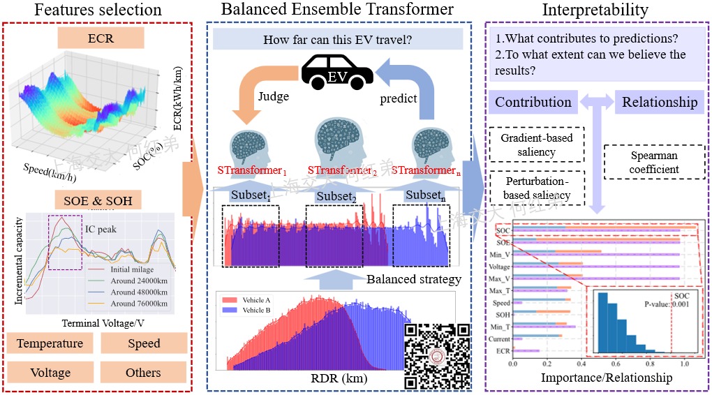
Energy efficiency not only directly reflects the performance and competitiveness of new energy vehicles but also serves as a key support for driving the green transformation and sustainable development of the industry. The research team has introduced dual-machine learning and small-bag-guided methods to conduct causal analysis of electric vehicle energy consumption and has developed a unified framework that integrates statistical, predictive, and causal perspectives. This framework has been empirically validated on large-scale multi-source driving data, revealing complementary insights that may be overlooked using a single method. This provides a new research path for deeply understanding the energy consumption mechanisms of electric vehicles, promoting eco-driving, and improving energy consumption prediction accuracy. Furthermore, based on large-scale real-world driving data, the research team uses statistical analysis methods to reveal the relationship between energy consumption and potential influencing factors at multiple levels, such as by city, vehicle type, and travel category, and quantifies the contribution of each variable to the energy consumption of new energy vehicles.
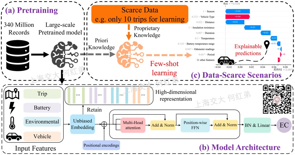
Based on the analysis of energy consumption patterns, the research team further focuses on the problem of electric vehicle remaining range prediction. In the early stages of vehicle deployment, traditional models often perform poorly in energy consumption prediction due to the lack of historical driving data. To address this issue, the research team proposed the Energy Consumption Transformer (ECT) model and designed a two-stage training strategy. In the first stage, the team pre-trains the model on 310,000 pieces of multi-type, multi-scenario driving data to learn the prior patterns of electric vehicle energy consumption. In the second stage, the model is fine-tuned using a small number of samples from the target vehicle to achieve personalized modeling. This model has zero-shot and small-sample modeling capabilities, significantly reducing the cold start threshold, and also showing remarkable advantages in cross-scenario generalization and deployment convenience. In real-world driving data, the vast majority of samples are concentrated in the mid-to-low range, while high-range samples are relatively scarce. Traditional single models are prone to prediction bias during training due to this imbalance. To address this problem, Professor He Hongdi's team, based on over 5 million pieces of electric vehicle operation data, systematically analyzed the relationship between energy consumption rate, vehicle speed, and battery status, and proposed the Balanced Ensemble Transformer (BET) model. This model first balances the distribution of remaining range segments through segmented sampling, then trains multiple dedicated Transformer sub-models. During the prediction phase, a dynamic routing mechanism is introduced to assign tasks to the most appropriate sub-model based on the current operational conditions, achieving accurate predictions across the entire range.
- Huang, Haichao, Bowen Li, Yizhou Wang, Zhe Zhang, and Hongdi He*. 2024. “Analysis of Factors Influencing Energy Consumption of Electric Vehicles: Statistical, Predictive, and Causal Perspectives.” Applied Energy 375: 124110.
- Huang, Haichao, Hongdi He*, Yizhou Wang, Zhe Zhang, and Tonggen Wang. 2025. “Energy Consumption Prediction of Electric Vehicles for Data-Scarce Scenarios Using Pre-Trained Model.” Transportation Research Part D: Transport and Environment 146: 104830.
- Zhang, Zhe, Qing Yu, Kun Gao, Hongdi He*, Yang Liu, and Haichao Huang. 2024. “Carbon Emission Reduction Benefits of Ride-Hailing Vehicle Electrification Considering Energy Structure.” Applied Energy, 124548.
- Huang, Haichao, Hongdi He*, and Zhong-ren Peng. 2024. “Urban-Scale Estimation Model of Carbon Emissions for Ride-Hailing Electric Vehicles during Operational Phase.” Energy 293:130665.
- 黄海超, 卢丹妮, 刘润, 何红弟(指导老师). 上海临港区域新能源汽车充电行为及充电桩优化研究, 2022, 上海智能新能源汽车大数据竞赛一等奖(1/492).
- 黄海超, 张哲, 李博文, 陈志恒, 王意洲, 何红弟(指导老师). 新能源汽车电池劣化的影响因素研究, 2023, 上海智能新能源汽车大数据竞赛二等奖(3/542).
UAV & Environment MonitoringUAV
Unmanned Aerial Vehicles (UAVs) have advantages such as strong mobility, simple operation, and low cost, and have been highly regarded in atmospheric environment monitoring in recent years. Equipped with portable air pollution monitoring devices, UAVs can conduct continuous monitoring of atmospheric pollutants at different altitudes and areas. This three-dimensional, comprehensive observation method breaks through the limitations of traditional ground-based fixed monitoring stations, more realistically revealing the vertical distribution characteristics and dispersion patterns of pollutants, providing key support for atmospheric pollution mechanism research and refined governance. Based on multi-rotor UAVs, the research group has set up portable air pollution monitoring equipment, and through wind tunnel tests and numerical simulations, established a UAV-based atmospheric pollution monitoring platform for refined monitoring of three-dimensional diffusion of atmospheric pollution. Main research directions include:

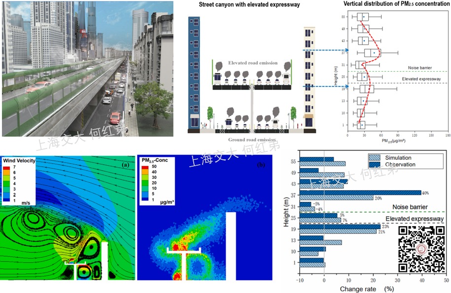
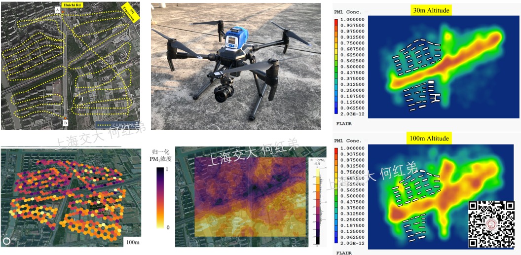


During operation, UAV propellers inevitably generate downwash airflow, which interferes with the sampling stability of portable monitoring devices. To address this, the research team uses numerical simulations, wind tunnel tests, etc., to optimize the configuration of portable devices on UAVs, compares UAV observation results with tethered balloon observations, reduces the impact of propeller airflow on monitoring data, and ensures accurate and reliable monitoring data.
The special three-dimensional structure of urban elevated roads usually hinders the diffusion of traffic pollutants, forcing pollutants to accumulate for long periods in elevated street canyons, leading to prolonged exposure of pedestrians on elevated roads to highly polluted air, seriously threatening their physical and mental health. Based on the UAV atmospheric pollution monitoring platform, the research team reveals the vertical distribution of pollutants in elevated road street canyons and uses numerical simulations to assess the environmental effects of elevated road infrastructure such as noise barriers. Street-side communities are close to main traffic arteries, and their air pollution is particularly severe. Residents' long-term exposure to high concentrations of air pollution has very serious health impacts. Based on the UAV atmospheric pollution monitoring platform, the research team reveals the three-dimensional spatiotemporal distribution of pollutants in street-side communities; uses deep learning algorithms to explore factors affecting the spatiotemporal distribution of pollutants; and combines numerical simulation to evaluate and optimize the spatial layout of building clusters in street-side communities.
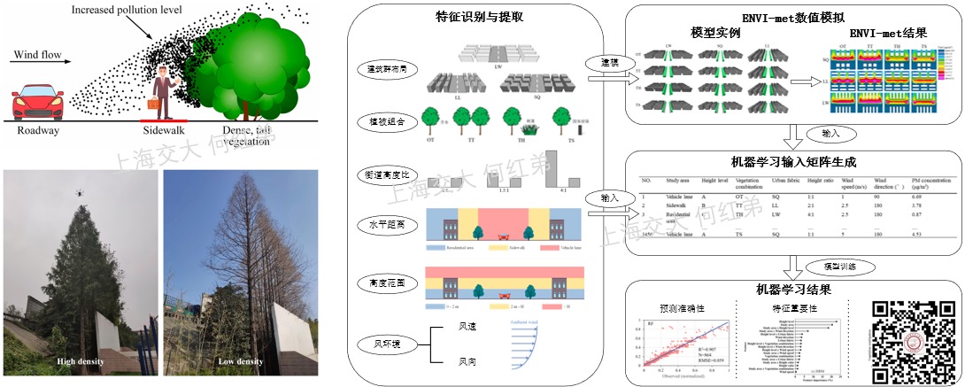
Road vegetation, on one hand, can adsorb traffic pollutants leading to concentration reduction, and on the other hand, its special three-dimensional structure hinders pollutant diffusion leading to concentration increase, resulting in ambiguous environmental effects of vegetation. The research team takes road vegetation as the research object, uses the UAV atmospheric pollution monitoring platform to explore the three-dimensional distribution patterns of vehicle exhaust when passing through or bypassing vegetation; and combines numerical simulation to reveal the effects of different vegetation layouts on pollutant diffusion and dissipation, further clarifying the synergistic mechanism between vegetation spatial patterns and road environment, meteorological conditions in the process of "dust interception and pollution reduction".
Traditional monitoring methods have significant limitations when applied in key areas such as industrial parks and steel plants, making it difficult to achieve refined monitoring of their emission sources. In contrast, UAVs have advantages such as flexibility, low cost, and wide spatial coverage, allowing for close-range, multi-altitude, multi-time-period observations around and even inside factory areas. The research team uses multi-source sensors mounted on UAVs to identify and analyze the spatial distribution and emission characteristics of pollution sources in steel plants, combined with real-time meteorological data to estimate pollutant diffusion paths and impact ranges.
To date, relying on the UAV monitoring platform, the research group has conducted vertical observation experiments of air pollutants in more than ten cities in the North China Plain, Yangtze River Delta, and Pearl River Delta, achieving relatively systematic research results. Related research not only provides key vertical observation data for regional air pollution source tracing but also provides strong support for local air pollution prevention and control decision-making.
- Chen, Z.H., Li, B.W., Li, B., Peng, Z.R., Huang, H.C., Wu, J.Q., He, H.D*. Identification of particle distribution patterns in vertical profile via unmanned aerial vehicle observations. Environ. Pollut., 2024, 348: 123893.
- Li, C., He, H.D*., Peng, Z.R. Spatial distributions of particulate matter in neighborhoods along the highway using unmanned aerial vehicles in Shanghai. Build. Environ., 2022, 211: 108754.
- Liu, X., Shi, X.Q., He, H.D*., Peng, Z.R*. Distribution characteristics of submicron particles influenced by vegetation in residential areas using instrumented unmanned aerial vehicle measurements. Sustain. Cities Soc., 2022, 78: 103616.
- Jiang, Y.H., Li, B., He, H.D*., Li, X.B., Wang, D.S., Peng, Z.R. Identification of the atmospheric boundary layer structure through vertical distribution of PM2.5 obtained by unmanned aerial vehicle measurements. Atmos. Environ., 2022, 119084.
- Song, R.F., Wang, D.S., Li, X.B., Li, B., Peng, Z.R., He, H.D*. Characterizing vertical distribution patterns of PM2.5 in low troposphere of Shanghai city, China: Implications from the perspective of unmanned aerial vehicle observations. Atmos. Environ., 2021, 265: 118724.
- 何红弟, 李白, 曹蓉, 鲁开发, 罗祯广. 一种用于大气环境三维监测的智能吊舱系统, 实用新型专利, 2022.
UAV Road InspectionROAD INSPECTION
Unlike general-purpose UAVs, the research group integrates multimodal sensors such as visible light, infrared, and LiDAR. Through UAV software-hardware co-design, key technologies including multi-payload configuration, center-of-gravity control, and data transmission are addressed, achieving system integration and optimized configuration of the UAV platform, gimbal cameras, multi-source sensors, and onboard computing devices to support efficient and stable data collection in complex traffic environments.

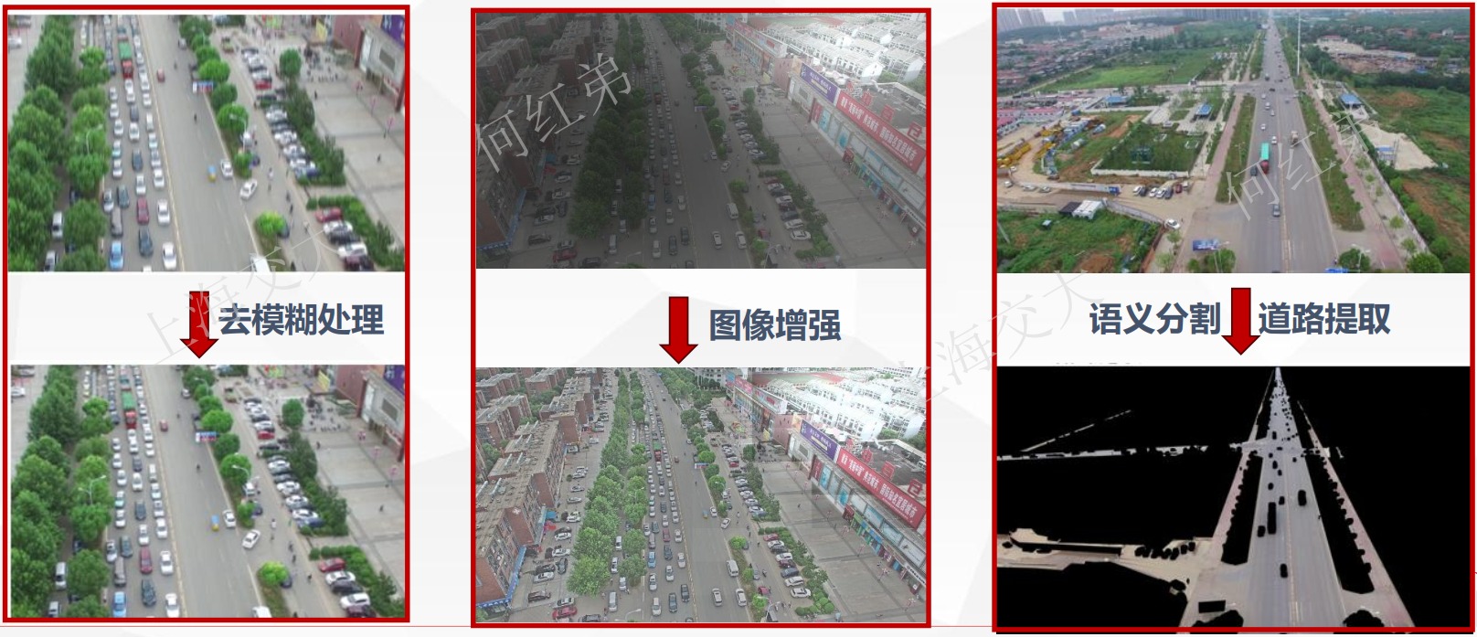
Addressing issues such as image jitter, motion blur, backlight interference, and large-area capture during UAV inspection, AI-based visual enhancement and intelligent preprocessing techniques are applied to optimize inspection images, improving image quality and target recognition accuracy in complex environments.
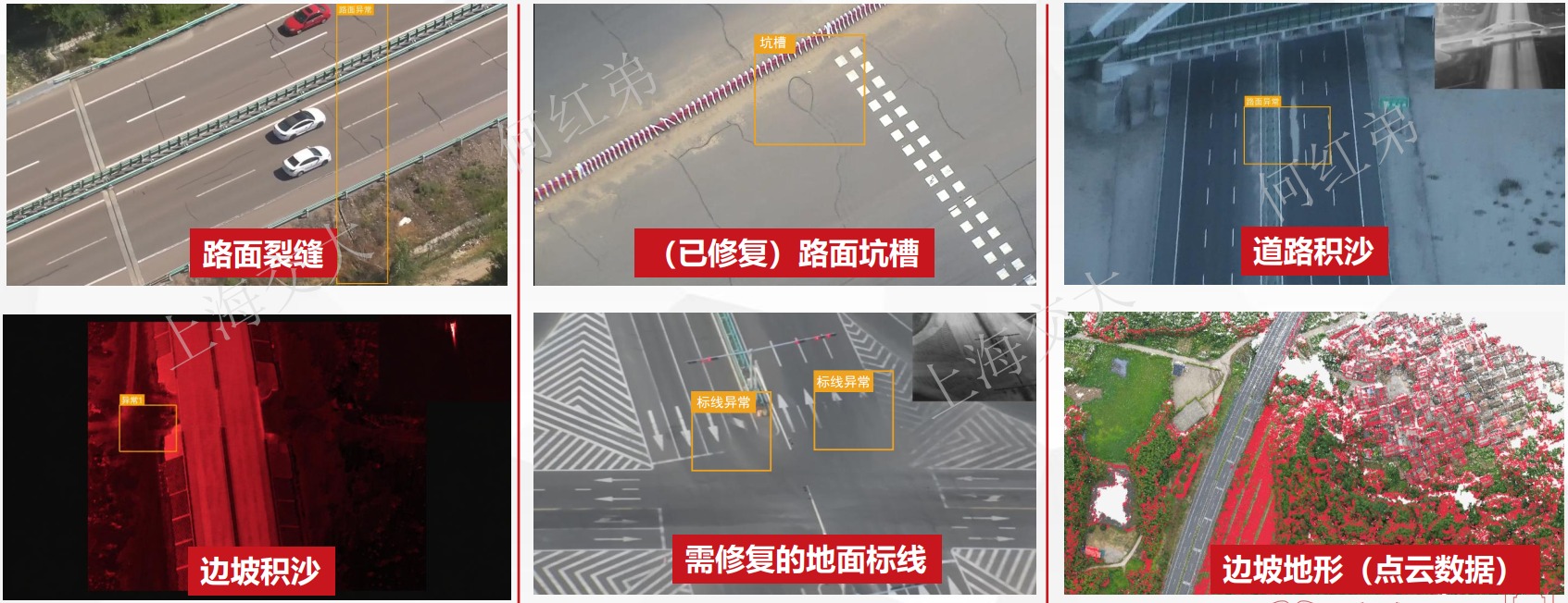
Using AI recognition algorithms, automatic detection, localization, and intelligent diagnosis of key targets such as pavement distress, road anomalies, slope deformation, and landslide risks are achieved, enhancing the capability to discover road safety hazards.
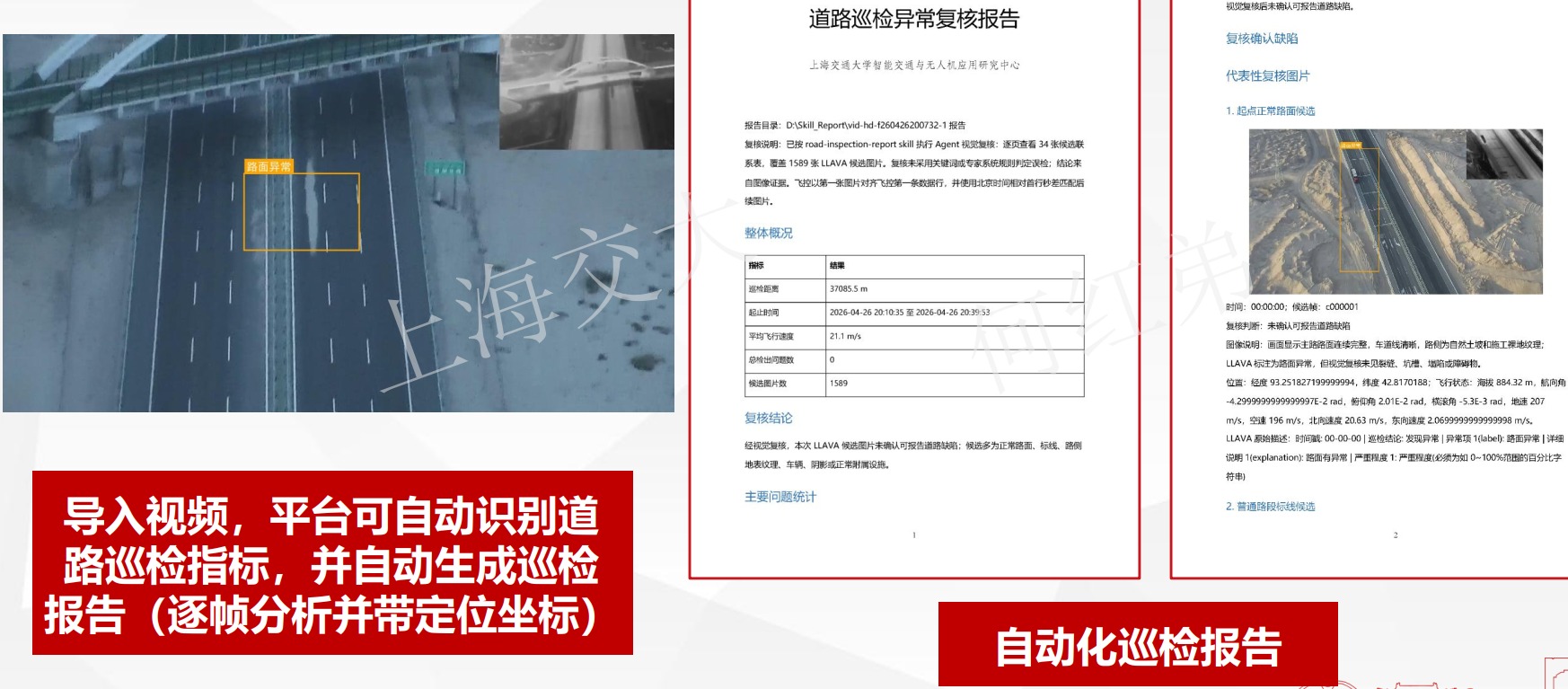
A road inspection intelligent analysis system has been developed to enable automatic parsing of inspection videos, automatic discovery of distress, intelligent risk assessment, and automatic generation of maintenance reports, providing technical support for the intelligent operation and maintenance of road facilities.
UAV Energy Facility InspectionENERGY INSPECTION
Wind power facilities are exposed to complex environments for extended periods, facing problems such as low manual inspection efficiency, high operational risk, and difficulty accessing certain areas. UAVs, with their advantages of aerial mobility, non-contact operation, and rapid information acquisition, provide new technical means for the intelligent inspection of wind power facilities.

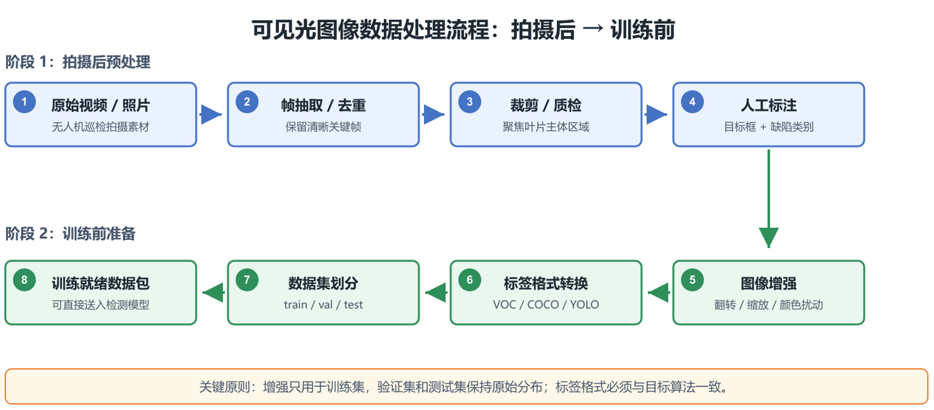
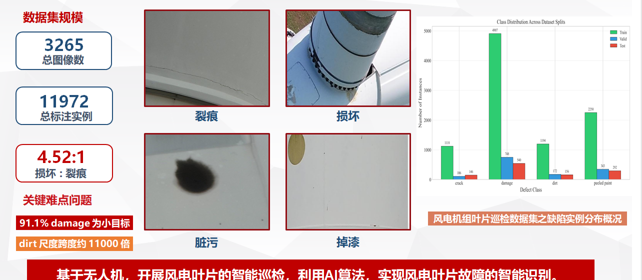
To address the difficulty of approaching wind power facilities, the research group constructs 3D digital scenes of wind turbines, conducts full-process simulation and practical verification of UAV inspection, and achieves autonomous takeoff, route planning, intelligent obstacle avoidance, and automatic inspection.
By fusing multimodal sensing information such as visible light and infrared, and using AI recognition algorithms, automatic recognition, localization, and severity assessment of typical defects such as blade cracks, lightning damage, leading-edge erosion, and surface spalling are achieved, providing data support for wind turbine operational status assessment and hidden danger investigation.
A wind power intelligent inspection analysis system has been developed to enable automatic parsing of inspection data, intelligent defect recognition, severity assessment, and automatic generation of inspection reports, providing technical support for the daily operation and maintenance, repair decision-making, and safety management of wind power facilities.